Names
Australian Placenames of German Background
Introduction | NT & WA | NSW | QLD | SA | TAS | VIC
Official placenames in Victoria today
➽ Albert Park - an inner suburb of Melbourne, 4 km south of Melbourne's Central Business District, on Boonwurrung Country. The name of the suburb came from the name of a public park there, named in 1864 to honour Prince Albert. Internationally Albert Park is perhaps best known as the location of the Formula One Australian Grand Prix race. Albert Park is one of several Australian places that were named after the German Prince Albert, who was married to Britain's Queen Victoria, and who became more and more admired by Britons in the later years of his life. You can read more about Prince Albert's connection with Australian place names in this article.
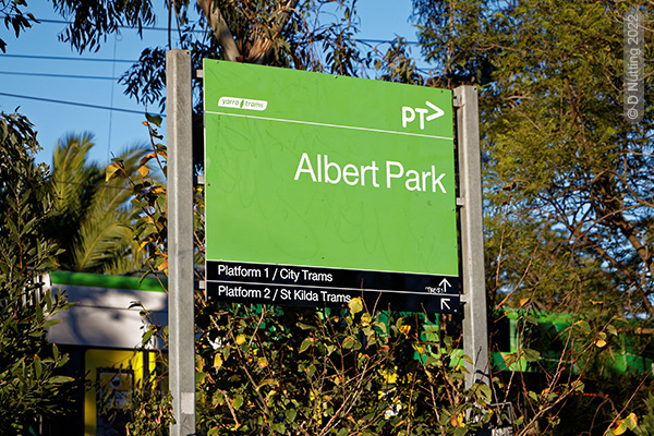
Sign at Albert Park, Victoria
➽ Alberton - a small town in South Gippsland, 7 kilometres south of Yarram and 216 kilometres east of Melbourne, on Kurnai Country. The township was surveyed in 1842. This is one of several Australian places that were named after the German Prince Albert, who was married to Britain's Queen Victoria, and who became more and more admired by Britons in the later years of his life. You can read more about Prince Albert's connection with Australian place names in this article.
➽ Altona - a suburb in the west of Melbourne, on Boonwurrung Country. Named after a suburb of Hamburg in Germany. You can read more about this place name and its origins in this article.
➽ Arkona - a hamlet situated about 310km west-northwest of Melbourne in Victoria's Wimmera region, on the Dimboola-Rainbow Road, on Wirgaia Country. You can read more about this place name and its origins in this article.
➽ Bismark - a locality about 35 km north of Stawell in the Wimmera. You can read more about this place name and its origins in this article.
➽ Brunswick - a suburb 5 km north of Melbourne's CBD, on Wurundjeri Country. Brunswick is the English name of Braunschweig, a city in northern Germany. You can read more about this Victorian place name and its origins in this article.
➽ Carlsruhe - a village 80 km north-west of Melbourne, on Taungurung and Wurundjeri Woiworung Country. Charles Hotson Ebden, pastoralist, overlander, businessman and politician, born at the Cape of Good Hope [South Africa] to wealthy parents, was educated in England and in Karlsruhe, Germany. He came to New South Wales and his stock were the first to cross the Murray River. In 1837 he settled on the Campaspe River west of Mount Macedon and named the area Carlsruhe after the German city. You can read more about this Victorian place name and its origins in this article.
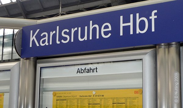
Railway station sign and trains timetable on a platform of the central station (Hbf = Hauptbahnhof) in Karlsruhe, Germany
➽ Coburg - a suburb 8 km north of Melbourne's CBD, on Wurundjeri Country. Coburg is a town in the Upper Franconia region of Bavaria, Germany. In March 1870 the Melbourne suburb was given the name Coburg to honour Britain's Duke of Edinburgh; he was a member of the German royal house of Saxony-Coburg-Gotha. You can read more about this Melbourne place name and its origins in this article.
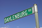
road sign: Dahlenburg Road
➽ Dahlen - a locality 9 km north-west of Horsham, on Jardwadjali Country. Dahlenburg Road is in fact not in Dahlen itself. Dahlenburg Road meets the Western Highway about 12 km east of Nhill. Dahlen was named after the Dahlenburgs, a settler family. In January 1949 the Horsham Times reported that Mr Wilfred Dahlenburg, of Dahlen, had won the Wimmera Wheat Competition. Mr Dahlenburg was a councillor of the Wimmera Shire. This competition judged the quality of wheat crops.
Source: HORSHAM GROWER WINS WIMMERA WHEAT COMPETITION (1949, January 18). The Horsham Times (Vic. : 1882 - 1954), p. 2. Retrieved August 24, 2023, from <http://nla.gov.au/nla.news-article73113949>.
➽ Elsternwick - a suburb 9 km south-east of Melbourne's CBD, on Boonwurrung Country. In the 1850s Charles Hotson Ebden [see Carlsruhe above] named his house there "Elster", the German word for "magpie". The suburb was named after his house. You can read more about this place name and its origins in this article.
➽ Freeburgh - a locality 10 km south-east of Bright, in Victoria's "High Country", on Waveroo land; the name may possibly be an English version of Fredeburg, the name of a village in Schleswig-Holstein in the north of Germany...but there are other possibilities too. You can read more about this place name and its origins in this article.
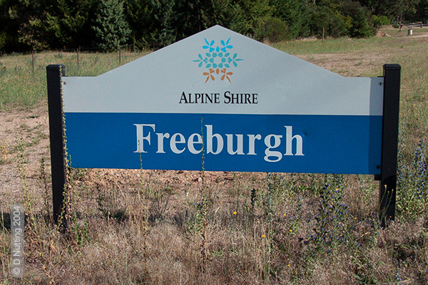
placename sign: Freeburgh
➽ Germantown - a locality 6.5 km southeast of Bright, on Waveroo Country; German Creek and Germantown were named after two Germans who found gold there and who were among the first settlers. You can read more about this place name and its origins in this article.
➽ Heidelberg - a suburb 11 km north-east of Melbourne's CBD, on Woiworung Country. You can read more about this place name and its origins in this article.
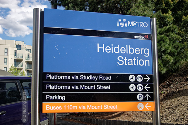
Sign at the entrance to the railway station at Heidelberg, Victoria
➽ Hesse - a locality on the Hamilton Highway 41 km from Geelong, on Wathaurong Country; named after George Hesse. In 1837 Hesse and Joseph Gellibrand, two Van Diemen's Land lawyers, explored the Upper Barwon district. You can read more about this place name and its origins in this article.
➽ Leichardt - a locality 21km north-west of Bendigo, on Djadjawurung Country. This place name is spelled without one of the two "h"s in Ludwig Leichhardt's name.
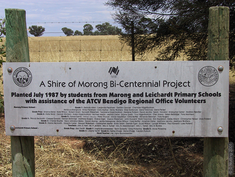
Commemorative sign in the locality named Leichardt, Victoria
The sign commemorates a project in which pupils from Leichardt Primary School participated. The school was closed in 1993. This placename has only one 'H' in the middle, unlike the other Australian places and landscape features named after Ludwig Leichhardt.
➜ See also Leichhardt's name in the Australian landscape...
➽ Lubeck - a village about 30 km east-south-east of Horsham in the Wimmera, on Jardwadjali Country. You can read more about this Australian and German place name and its origins in this article.
➽ Mont Albert - Mont Albert is an inner eastern suburb of Melbourne, 12 kilometres east of Melbourne's Central Business District, on Woiworung Country. Mont Albert is one of several Australian places that were named after the German Prince Albert, who was married to Britain's Queen Victoria, and who became more and more admired by Britons in the later years of his life. You can read more about Prince Albert's connection with Australian place names in this article.
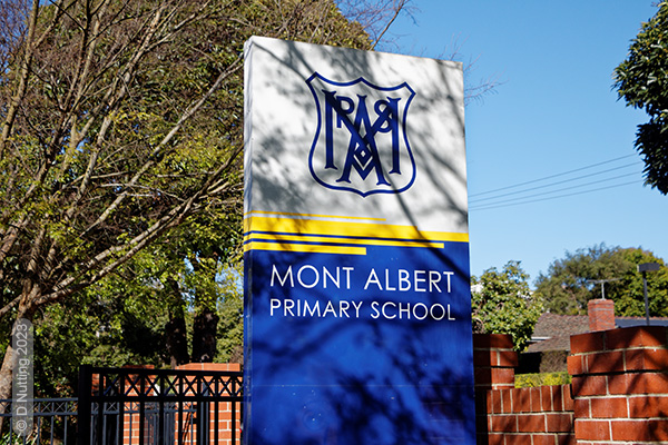
Sign at Mont Albert Primary School.
➽ Port Albert - a coastal town in South Gippsland, on the shores of Corner Inlet, 82 kilometres south-east of Morwell, on Kurnai Country. Port Albert is one of several Australian places that were named after the German Prince Albert, who was married to Britain's Queen Victoria, and who became more and more admired by Britons in the later years of his life. You can read more about Prince Albert's connection with Australian place names in this article.
➽ Rucker's Hill - a neighbourhood within the suburb of Northcote, about 5 km north-east of the Melbourne CBD, on Wurundjeri Woiwurrung Country. You can read more about this place name and its origins in this article.
➽ Sebastian - a village and locality about 22 km north of Bendigo. You can read more about this place name and its origins in this article.
➽ Steiglitz - a hamlet north-west of Geelong, on Wathaurong Country; named after the Irish-German brothers Von Steiglitz. You can read more about this place name and its origins in this article.
Former German placenames in Victoria
In earlier times Australia had many more German placenames, but local residents and governments have changed many names. Most of the German names in the following list were changed during the First World War. However, a few of the placenames listed below were not changed, though they are today very small rural localities without postcodes, where the old German place name has simply dropped out of common usage. Most German immigrants in the 19th century settled in rural areas.
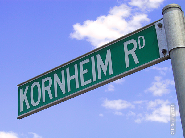
road sign: Kornheim Road
➽ Berlin - now Rheola, a village approximately 60km west-northwest of Bendigo in Central Victoria. You can read more about this place name and its origins in this article.
➽ Breslau - an area 20 km east of Melbourne's CBD, on Wurundjeri Country. Around 1856 it was renamed Waldau, since ~1900 Doncaster; a Primary School in Doncaster that existed from 1971 until 1996 (when a school merger occurred) was called Waldau Primary School (State School No. 5008).
The first Germans in the Doncaster area settled in the vicinity of today’s Victoria, King and George Streets. (Until 1916 these streets were called Bismarck Street, Wilhelm Street and German Lane or Waldau Lane respectively.) Pastor Matthias Goethe of the Trinity Lutheran Church in Melbourne published a church newspaper called Der Pilger in Victoria, and in the edition of 30/09/1853 a notice announced the following (here in translation):
The German settlement of Breslau. Several German families recently purchased 750 acres of land in the vicinity of Templestowe on the Yarra about ten miles from Melbourne. There they intend to establish a German village to be called Breslau.
Der Pilger in Victoria, 30/09/1853
The settlers probably chose the name Breslau because many of them were originally from the Prussian province of Silesia. Breslau is a major city with a reputable university in Silesia. When Germany’s borders were changed after the Second World War Breslau and most of Silesia became Polish territory and Breslau is known as Wrocław in Polish. There are places in North America named after the German/Polish city of Breslau. A village in Ontario, Canada, is named Breslau, and a locality in Nebraska, USA, carries the same name.
By 1860 the name of the village Breslau in Victoria had changed to 'Waldau', but the exact time of this change and why it occurred are not known. Waldau means ‘clearing in a forest’. A recreational area of about 20 hectares in the Doncaster area is called the Waldau Precinct. Manningham City Council's 'Waldau Precinct Masterplan' described the Precinct as as "one of Manningham’s most loved recreational areas". There are villages named Waldau in the German states of Saxony-Anhalt and Baden-Württemberg.
Sources: Darragh, Thomas & Robert Wuchatsch. (1999). From Hamburg to Hobson's Bay: German emigration to Port Phillip (Australia Felix) 1848-51. Heidelberg (Victoria): Wendish Heritage Society. p.133 / Collyer, Eric. (2022, January). Lutheran Settlement at Waldau. (Presentation to General Meeting of the Doncaster Templestowe Historical Society). Available online at: <https://dt-hs.blogspot.com/2022/02/lutheran-settlement-at-waldau.html> / Blake, L. J. (general editor) & Education Department of Victoria. (1973). Vision and realisation : a centenary history of state education in Victoria. Melbourne: Education Department of Victoria. Volume 3, p.536 / Wuchatsch, Robert. (1985). Westgarthtown. The German settlement at Thomastown. Self-publication. p.52
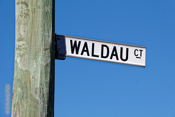
Street sign of Waldau Court, a street name that acknowledges the historical German name of the area.
➽ Germantown - now Grovedale, near Geelong, on Wathaurong Country. You can read more about this place name and its origins in Geelong in this article.
➽ Gnadental - near Penshurst, east of Hamilton, on Gunditjmara Country.
➽ Grünwald - now Arkona, a short distance northwest of Dimboola, on Wergaia Country. See the article about the name Arkona.
➽ Hochkirch - now Tarrington, 5 km southeast of Hamilton, on Gunditjmara Country. You can read more about this place name and its origins in this article.
➽ Kirchheim - was a very small village 6 km south-west of Minyip, on Jardwadjali Country, 320 km north-west of Melbourne. The population decreased and in 1935 the weatherboard St John's Lutheran church was moved by steam traction engine to its present site in Minyip.
Source: 'Minyip'. Lifestyle, Travel. Sydney Morning Herald. February 8, 2004. <https://www.smh.com.au/lifestyle/minyip-20040208-gdkque.html> Accessed 15/04/2023.
➽ Kornheim - about 7 km east of Dimboola, on Wergaia Country. The first German settlement in the Wimmera region was established in 1871 with the name Kornheim, east of Dimboola. A Lutheran church was built there in 1874, and the Katyil post office, which had existed since the 1st February 1883, was renamed Kornheim Post Office on the 1st October 1883. During the anti-German sentiment in the First World War, this post office was renamed Edolsfield RO (= Receiving Office, i.e. a kind of part-time post office that did not offer all the services of a post office) in November 1917, and the post office here was closed in May 1921.
Sources: Lodewyckx, Prof. Dr. A. (1932). Die Deutschen in Australien. Stuttgart: Ausland und Heimat Verlagsaktiengesellschaft. p.55 / Phoenix (Philatelic) Auctions - Post Office List, at <www.phoenixauctions.com.au>
➽ Neukirch - Byaduk, near Hamilton, on Gunditjmara Country. The early Wendish settlers called their community Neukirch ('new church').
➽ New-Mecklenburg - from 1850 known as Keelbundora; ~1851 Dry Creek; ~1855 New Mecklenburg; ~1860 Westgarthtown; since ~1900 Thomastown, a suburb in the north of Melbourne, on Woiworung Country.
➽ Plauen - now Mill Park, a suburb 18 km north-east of Melbourne's CBD, on Woiworung Country. Plauen is a city in the south-west of the German state of Saxony, close to the borders with the states of Thuringia and Bavaria. In January 1851 the Argus newspaper mentioned Germans living and working at “Plauen (River Plenty, Mr Miller’s place)”. Plauen was five kilometres east of Westgarthtown. By 1860 all those Germans had left to buy their own land at other places.
Source: Darragh, Thomas & Robert Wuchatsch. (1999). From Hamburg to Hobson's Bay: German emigration to Port Phillip (Australia Felix) 1848-51. Heidelberg (Victoria): Wendish Heritage Society, p.129.
➽ Tanck's Corner - a town 25km north-east of Melbourne's CBD, on Woiworung Country. Named after the settler Friedrich Tanck, 1871 - since 1929 Yarrambat. Tanck’s Corner Primary School opened in 1878, but the name was changed in 1929 when the wife of the head teacher persuaded the community that "a more appropriate" name was needed. The authorities agreed to the new name of Yarambat.
Source: Blake, L. J. (general editor) & Education Department of Victoria. (1973). Vision and realisation : a centenary history of state education in Victoria. Melbourne: Education Department of Victoria. Volume 3, p.81.
➽ Mt Bismarck - now Mt Kitchener, a mountain (953m) south of Marysville, about 25 km north-east of Healesville. One of the unsealed dirt roads near Mt Kitchener still has the name Bismarck Track, however. You can read more about the name Bismarck in Australia in this article.
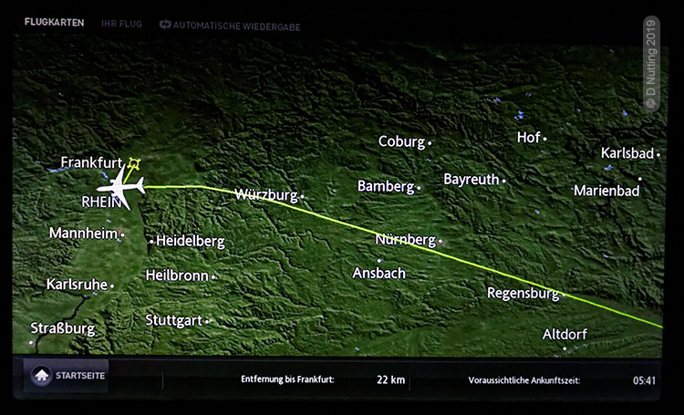
A flight-tracking map of Germany displayed in the interior of a passenger jet during its approach to Frankfurt. The map shows the names of three German cities that are also place names in Victoria (Coburg, Heidelberg, Karlsruhe).
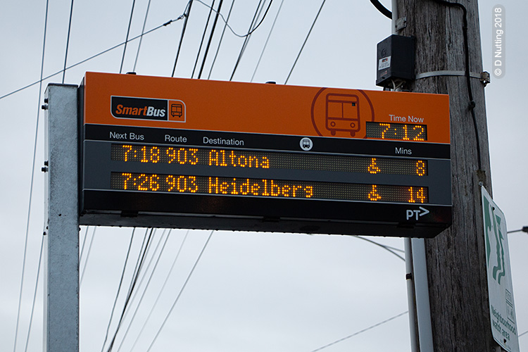
A bus route in Melbourne reaches two suburbs with German names - Heidelberg and Altona, displayed at this bus-stop. In Germany Heidelberg is in the south and Altona is in the north - in Melbourne their geographic positions are almost the opposite.
♦ References:
Blake, L. J. (1976). Place names of Victoria. Adelaide: Rigby.
Nutting, David. (2004). German placenames in Victoria. PLACENAMES AUSTRALIA. Newsletter of the Australian National Placenames Survey. September, 2004. pp.4-5