Names
Australian Placenames of German Background
Introduction | NT & WA | NSW | QLD | SA | TAS | VIC
Official placenames in Queensland today
➽ Alberton - a rural locality about 45 km north of Surfers Paradise, on Yuggera / Bundjalung Country. European settlement, mainly German immigrants, started in 1863. This is one of several Australian places that were named after the German Prince Albert, who was married to Britain's Queen Victoria, and who became more and more admired by Britons in the later years of his life. You can read more about Prince Albert's connection with Australian place names in this article.
➽ Bergen - a rural locality 40 km north of Toowoomba, on Barunggam Country.
➽ Hebel - a small town 650 km west-south-west of Brisbane, close to the border with NSW, on Yuwaalaraay Country. Hebel was once known as Kelly’s Point. It wasn’t until the early 1890s that the name changed to Hebel, most likely after a local German family residing in the town. Mr Von Hebel (or Mr Hebel) is said to have played a role in staging the Cobb & Co. Coaches.
The writer Mike Whitcomb compiled a local history book about Hebel, and believes that “a Germanic link with the name seems undeniable”, though there is no definite information about the origin of the place name. Laurie Hoare, a former postmaster in Hebel, travelled in Germany and was told there that the son of an aristocratic family named von Hebel (whose castle was on the banks of the Rhine) had emigrated to Queensland in the 1880s. In Germany there is a hamlet named Hebel in central Germany, 28 km south-south-west of Kassel. There is another hamlet named Hebel in north-western Germany, 13 km north-west of Meppen, close to the Dutch border.
Sources: St George Region Pub Trail (brochure). (2021). St George (QLD): Balonne Shire Council. p.4 / Whitcomb, M. R., editor. (1989). Hebel Hallmarks: A Local History. Toowoomba: Harrison Printing. p.27
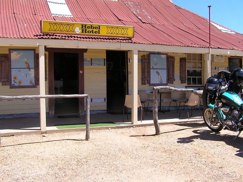
The Hebel Hotel, Queensland
Photo source: Jules Hawk at Flickr, under a Creative Commons licence (CC BY-NC-ND 2.0), 2011.
➽ Leichhardt - a suburb three km south-west of central Ipswich, on Yuggera Country; was known as One Mile until 1956. In 1930 One Mile Park to the west of the Bremer River was renamed Leichhardt. It's claimed that the explorer Ludwig Leichhardt camped there. The suburb that developed was named Leichhardt in 1956, the year the primary school was opened.
Source: 'Leichhardt'. Queensland Places. (2018). <https://queenslandplaces.com.au/leichhardt> Centre for the Government of Queensland at the University of Queensland. Accessed on 09/02/2023.
➽ Marburg - a village 57 km west-south-west of Brisbane, on Yuggera Country. You can read more about this place name and its origins in this article.
➽ Minden - a rural locality 64 km west of Brisbane's CBD, on Yuggera Country. You can read more about this place name and its origins in this article.
➽ Prenzlau - a locality in the Lockyer Valley in south-eastern Queensland, on Yuggera Country. You can read more about this place name and its origins in this article.
➽ Rosenthal Heights - a rural locality south-west of Warwick, on Bundjalung Country. Frederick John Henry Bracker (1798–1870, presumably originally Friedrich Johann Heinrich Bracker in his homeland) was from Mecklenburg in north-eastern Germany and an expert in managing merino sheep. From 1843-1849 he managed a run (sheep station) near Warwick which he named Rosenthal (English: valley of roses). Later on the name Rosenthal was applied to the parish and to a creek.
Source: 'Rosenthal Heights'. Queensland place names search. Queensland Government. (Reference no. 45972). Online here.
➽ Sellheim - a locality about 18 km north-east of Charters Towers, on Gugu-Badhun Country, and named after the German immigrant Philipp Friedrich Sellheim. Sellheim was born in the village of Konradsdorf 35km north-east of Frankfurt am Main. He studied sheep-breeding at academies in Berlin and in Upper Silesia and emigrated to Australia in 1855. Sellheim managed sheep stations for a while and later the Queensland government appointed him warden on the Palmer goldfield. He established a good reputation as a leader and mine inspector on several goldfields (including from 1880-1888 on the Charters Towers goldfield) and in 1892 he became Under Secretary for Mines in the Queensland Government. Philipp Sellheim was "one of Queensland's most honest and effective civil servants in the nineteenth century."
Source: Bolton, G. C. (1976). 'Sellheim, Philip Frederic (1832–1899)', Australian Dictionary of Biography, National Centre of Biography, Australian National University, <https://adb.anu.edu.au/biography/sellheim-philip-frederic-4555/text7471>, published first in hardcopy 1976, accessed online 14 February 2023.
➽ Steiglitz - a rural coastal town and locality about 54km south-east of Brisbane's CBD, on Bundjalung Country. Many German families settled in the area in the 1870s. One of the immigrant families, the Kleinschmidts, came from Stegelitz in the Uckermark region of north-eastern Germany. In several official documents the name was spelled Stegelit for a considerable period of time, for example in Pugh's official almanac, directory and gazetteer (an annual commercial guide to Queensland businesses, places and events). In the 1914 entry for "Stegelit" more than 110 people are listed under the heading ›Trades and professions‹, most of them farmers - almost all of the names are German. In the course of time the spelling of the place name became Steiglitz.
Source: 'Steiglitz'. Queensland Places. (2018). <www.queenslandplaces.com.au/steiglitz> Centre for the Government of Queensland at the University of Queensland. Accessed on 16/04/2023. / (1915). STEGELIT., Pugh's (Queensland) official almanac, directory and gazetteer for 1915. Brisbane: Edwards Dunlop & Co., Ltd. pp.749-750. Retrieved April 16, 2023, from <http://nla.gov.au/nla.obj-3065787478> pp.749-750
➽ Templin - a rural locality in the Scenic Rim region, on Bundjalung Country, approximately 70 km south-west of Brisbane. Templin is a town in the West-Uckermark area of Germany, about 80 km northeast of Berlin. You can read more about this place name and its origins in this article.
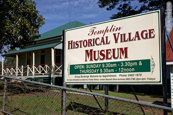
Sign at the front of the Templin museum in Queensland
➽ Wartburg - a rural locality approximately 60 km north-west of Bundaberg. You can read more about this place name and its origins in this article.
➽ Wolfram - a ghost town 90 km south-west of Cairns, on Kuku-yalanji Country. It was a mining town that developed after the discovery of the mineral wolframite there in 1891. In its heyday the town of Wolfram had a school, a hospital, a bakery, several stores and several hotels. The word Wolfram is a somewhat outdated German proper noun - a male Christian name, and it is also the German name of the chemical and mineral element known in English as tungsten. (Tungsten's chemical symbol is W, derived from the name Wolfram.) The name tungsten is used in Nordic countries and in English-speaking and French-speaking countries, while most European countries use the name wolfram. The name wolfram is derived from the Old-High-German terms wolf (wolf) and ram (raven).
Source: 'Wolfram'. Queensland Places. Centre for the Government of Queensland. <https://queenslandplaces.com.au/wolfram>. / 'Wolfram'. (2 February 2023). Wiktionary. Accessed 7 April 2023, 12:54 at <https://de.wiktionary.org>. / Helmenstine, Anne Marie, Ph.D. (2021, February 16). Tungsten or Wolfram Facts. Retrieved from <www.thoughtco.com/tungsten-or-wolfram-facts-606610>.
➽ Zillmere - a suburb about 13 km north of Brisbane's CBD, on Turrbal Country. The name Zillmere is derived from "Zillman's Waterhole" - Johann Leopold Zillmann, one of the early missionaries whom John Dunmore Lang brought to Queensland.
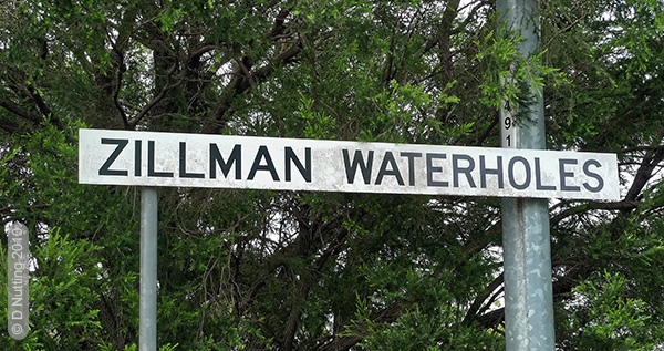
Sign at Zillmere in Queensland
Former German placenames in Queensland
In earlier times Australia had many more German placenames, but local residents and governments have changed many names. Most of the German names in the following list were changed during the First World War. However, a few of the placenames listed below were not changed, though they are today very small rural localities without postcodes, where the old German place name has simply dropped out of common usage. Most German immigrants in the 19th century settled in rural areas.
➽ Bismarck - now Maclagan, a small town on the Darling Downs, 80 km north-west of Toowoomba, on Barunggam Country.
➽ Blumbergville - now Boonah, a rural town and locality in the Scenic Rim Region, 86 km south-west of Brisbane, on Bundjalung Country.
➽ German Bridge - Holland Park is a southern suburb of Brisbane, approximately 9 km from the CBD, on Yuggera Country. Part of Holland Park was known as 'German Bridge' for a long time. You can read more about this place name and its origins in this article.
➽ German Gardens - now Belgian Gardens, an inner coastal suburb of Townsville in northern Queensland, on Nyawaygi/Bindal Country. The area was known in the 19th century as German Gardens, due to a vineyard or market garden there owned in 1867 by a settler from Hamburg, Germany. He was Heinrich Friedrich Alfred Robinson (1842-1900), a name which seems almost a hybrid German-English name.
In a very short announcement under the heading "CHANGE FOR THE BETTER" the Cairns Post reported the following in January 1915, during the First World War: "The name of the "German Gardens" at Townsville has been altered to "Belgian Gardens"."
Source: 'Belgian Gardens'. Queensland place names search. Queensland Government. (Reference no. 44570) / CHANGE FOR THE BETTER. (1915, January 13). Cairns Post (Qld. : 1909 - 1954), p.4. Retrieved September 2, 2021, from <nla.gov.au/nla.news-article42920763>
➽ Hessenburg - now Ingoldsby, a rural locality in the Lockyer Valley Region, 82 km west-southwest of Brisbane, on Barunggam Country.
➽ Engelsburg - now Kalbar, a rural town and locality in the Scenic Rim Region, 82 km south-west of Brisbane, on Bundjalung Country. You can read more about this place name and its origins in this article.
➽ Gehrkevale - now Mount Mort, a rural locality about 40 km south-west of Ipswich, on Yuggera Country. Carl Friedrich Wilhelm Gehrke arrived in Australia in 1871 and bought several properties in the area that eventually became known as Gehrkevale. In 1906 the newspaper The Queenslander described him as follows: "Mr. Gehrke is one of those hard working Germans that make such good settlers." The place name was changed during the First World War.
Source: "THE MEN UPON THE LAND." (1906, February 17). The Queenslander (Brisbane, Qld. : 1866 - 1939), p. 29. Retrieved April 15, 2023, from <http://nla.gov.au/nla.news-article20823077>
➽ German Station - an early German mission station, established in 1838; since 1885 the place has had the name Nundah, an inner suburb north-northeast of central Brisbane, on Yuggera Country.
➽ Gramzow - now Carbrook, a suburb 38 km south-east of central Brisbane, on Yuggera Country. Hermann Meisenner and other families named their settlement on the Logan River Gramzow after a small village from which several of them came, in the Uckermark area of north-eastern Germany, near Prenzlau. In 1875 members of the community finished building the Church of St Paul 'in a traditional north German style with hand made brick nogging in a timber frame that had been axe dressed and fixed with wooden pegs. This church was demolished in 1951 and a new church built on land at Mt Cotton.' The name Gramzow was changed in 1916 during the First World War.
Source: 'Carbrook Lutheran Cemetery'. (2022). Queensland Heritage Register. <https://apps.des.qld.gov.au/heritage-register/detail/?id=601660#> Accessed 15/04/2023.
➽ Hapsburg - was the name of a railway siding or railway station. The name was changed to Kowbi in 1916 by the Railways Department. Kowbi is a locality about 270 km north-northwest of Brisbane, not far from Childers, on Gubbi Gubbi Country. The railway station no longer exists.
Source: 'Kowbi'. Queensland place names search. Queensland Government. (Reference no. 18532). <https://www.resources.qld.gov.au/qld/environment/land/place-names/search>.
➽ Kirchheim - now Haigslea, a locality 17 km north-west of Ipswich, on Yuggera Country. It was renamed during the First World War.
➽ Roessler - now Applethorpe, a rural town and locality in the Southern Downs Region, 213 km south-west of Brisbane, on Ngarabal/Bundjalung Country. Early orchardists and vignerons were the Roessler family, who gave their name to the village. The name was changed to Applethorpe in 1915.
Source: 'Amiens, Thulimbah, Applethorpe District'. Queensland Places. (2018). <https://queenslandplaces.com.au/amiens%2C-thulimbah%2C-applethorpe-district> Centre for the Government of Queensland at the University of Queensland. Accessed on 16/04/2023.
➽ Teutoburg - now Witta, a rural town seven km north-west of Maleny in the Sunshine Coast region, on Gubbi Gubbi Country. You can read more about this place name and its origins in this article.